
AI-Powered Campus Navigation with BLE Positioning and Location Intelligence
AI-Powered BLE Campus Navigation System Architecture
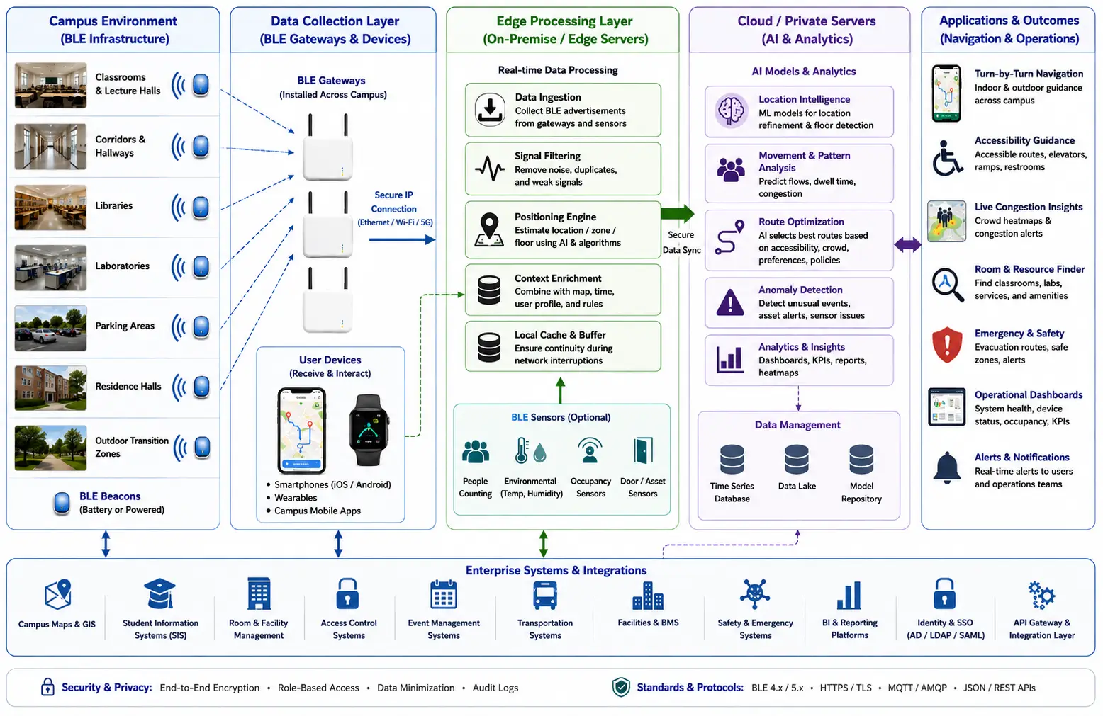
This visual illustrates how BLE beacons, gateways, edge AI processing, campus maps, smartphones, and wearable devices work together to provide real-time indoor and outdoor campus navigation. It highlights the flow of location and sensor data from campus infrastructure to user-facing navigation applications.
How AI Improves BLE-Based Campus Navigation
AI-powered campus navigation combines location intelligence with Bluetooth Low Energy (BLE) infrastructure to determine where people and selected assets are located, estimate movement patterns, and provide context-aware routing across complex university environments. BLE beacons transmit identifiers at defined intervals, while BLE gateways, smartphones, and BLE-enabled sensors collect signal observations that can be processed to estimate position. AI can improve this process by filtering noisy measurements, recognizing movement patterns, estimating occupancy, predicting congestion, and selecting routes based on changing campus conditions.
For universities, the objective is not simply to display a map. A practical campus navigation system must address indoor positioning, multi-building movement, accessibility requirements, changing room availability, emergency conditions, pedestrian congestion, and integration with existing campus information systems. GAO provides BLE, RFID, and IoT hardware products and systems that can support these location-based applications.
BLE-Enabled Smart Campus Navigation with Indoor and Outdoor Wayfinding
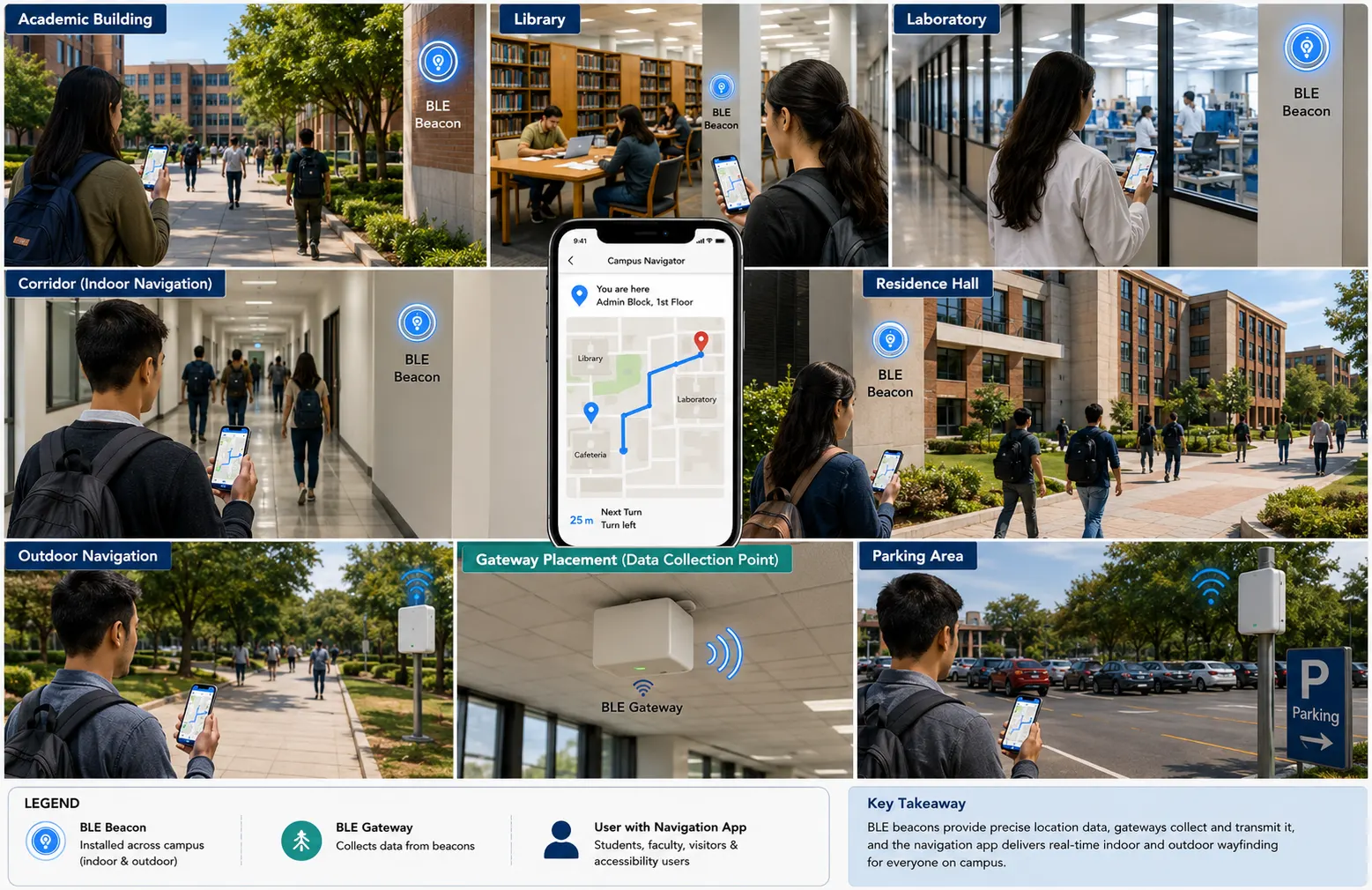
This visual showcases a realistic university campus where students, faculty, visitors, and accessibility users navigate indoor and outdoor spaces using a mobile navigation app. It illustrates BLE beacons installed across campus, BLE gateways collecting location data, and real-time wayfinding across academic buildings, libraries, laboratories, residence halls, corridors, and parking areas.
BLE Positioning Fundamentals for Campus Navigation
BLE provides the radio infrastructure needed to observe proximity and signal behavior throughout campus buildings. A typical deployment uses several complementary components:
- BLE beaconsbroadcast identifiers that allow mobile devices or nearby receivers to recognize specific locations or zones.
- BLE gatewayscollect BLE advertisements and forward observations to edge servers or cloud-hosted software.
- BLE sensorscan provide additional environmental or occupancy-related measurements where required.
- Mobile devicescan use received BLE signals for proximity detection and, depending on the implementation, positioning calculations.
- Edge serverscan process signal observations close to the campus network to reduce latency and limit unnecessary data transmission.
- Cloud or privately hosted serverscan provide centralized analytics, AI processing, mapping services, dashboards, and system management.
- Campus maps and geographic dataprovide the spatial context needed to convert positioning information into usable navigation instructions.
BLE positioning should not be treated as a single universal accuracy technology. Real-world accuracy depends on beacon density, antenna characteristics, building materials, floor layout, radio interference, device orientation, installation height, calibration, and the positioning method selected.
Common positioning techniques include RSSI-based proximity estimation, fingerprinting, trilateration-style calculations, and hybrid approaches. AI can complement these methods by learning relationships between signal observations and known locations, reducing the impact of unstable RSSI measurements, and recognizing movement states such as stationary, walking, entering a building, or moving between floors.
For campus environments, wayfinding accuracy at decision points is often more important than a theoretical average positioning accuracy. A navigation system that reliably determines whether a user is approaching the correct corridor, elevator, staircase, or building entrance can be more useful than one that reports a highly precise coordinate but frequently jumps between locations.
Campus Navigation Applications for AI and BLE
Indoor Wayfinding Across Academic Buildings
Large academic buildings can contain multiple floors, corridors, laboratories, lecture halls, faculty offices, libraries, and restricted areas. BLE beacons can establish recognizable navigation zones while AI processes location observations and movement patterns.
The navigation software can guide a user from an entrance to a particular classroom while accounting for floor transitions and accessible routes. For example, an accessibility-aware route can prioritize elevators instead of stairs when the user’s selected navigation profile requires it.
Key engineering considerations include:
- Beacon placement near corridor intersections and other navigation decision points
- Floor-level identification
- Accurate representation of elevators, stairs, ramps, and restricted areas
- Periodic radio-site surveys and beacon maintenance
- Handling signal changes caused by walls, doors, people, and furniture
- Synchronization between physical campus changes and digital maps
Student and Visitor Navigation
Visitors may arrive without knowledge of campus building layouts. BLE-assisted navigation can provide turn-by-turn guidance from parking areas, campus entrances, reception points, or visitor centers to destinations such as admissions offices, auditoriums, libraries, or event locations.
AI can improve routing by considering historical pedestrian flows and temporary conditions. During a major campus event, for example, the preferred route may change because a corridor is congested or a building entrance has been temporarily closed.
Accessibility-Aware Campus Navigation
Accessibility is an important campus-navigation requirement because the shortest physical route is not necessarily the most appropriate route.
A location-aware system can maintain route attributes such as:
- Accessible entrances
- Ramps and elevators
- Staircases
- Door restrictions
- Accessible restrooms
- Temporary construction barriers
- Steep pathways
- Indoor and outdoor transition points
AI-based route selection can use these attributes together with current location and destination information to select a route that satisfies the user’s requirements rather than simply minimizing distance.
Emergency and Evacuation Guidance
Campus navigation can also support emergency response when integrated with authorized campus safety systems. BLE location observations can help determine affected zones, while navigation software can provide updated directions when normal routes become unavailable.
Emergency routing should be designed carefully. Life-safety decisions should rely on validated emergency procedures and authoritative campus safety information rather than an AI model acting independently. AI can assist with route analysis, anomaly detection, and operational decision support, while approved emergency systems remain the source of authoritative instructions.
BLE-Driven Campus Navigation Workflow: From Signal Capture to AI-Powered Routing
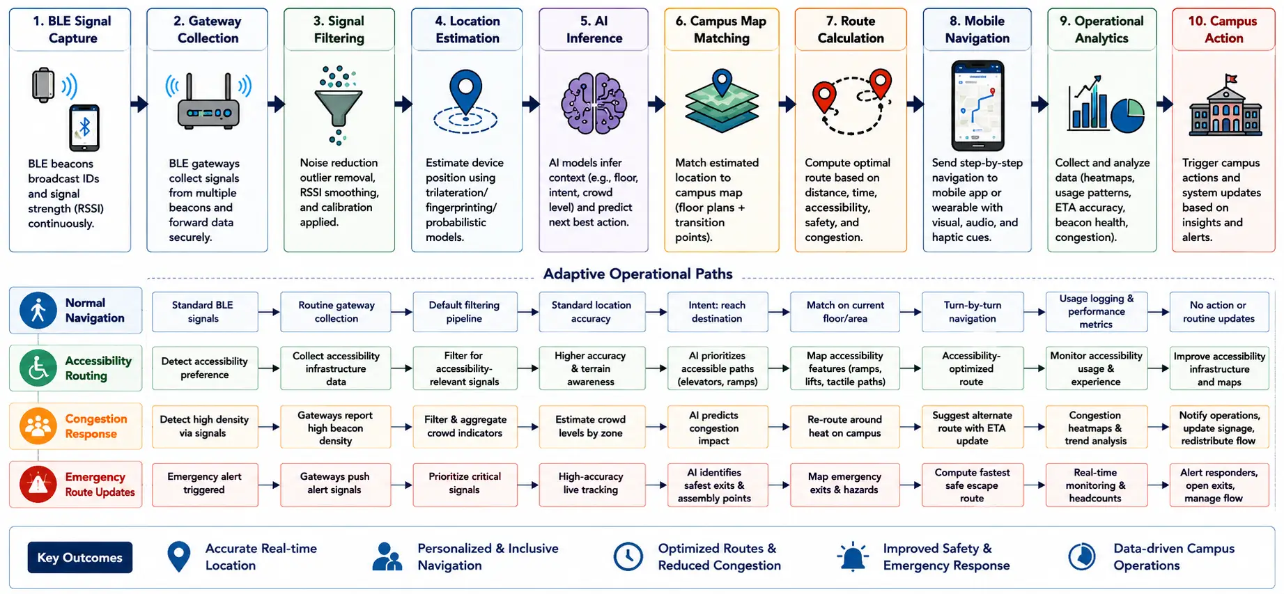
This workflow diagram illustrates how BLE signals move from beacon capture and gateway collection through signal filtering, location estimation, AI inference, map matching, route calculation, and mobile navigation. It also shows adaptive pathways for normal navigation, accessibility routing, congestion response, and emergency route updates, demonstrating how BLE and AI support responsive campus operations.
From BLE Data Capture to AI-Driven Campus Decisions
A practical campus navigation deployment typically operates as a continuous data workflow rather than a standalone mobile application.
Data Acquisition
BLE beacons transmit advertisements at configured intervals. Smartphones, gateways, and other BLE receivers observe these transmissions and generate measurements such as received signal strength, beacon identifier, receiver identity, and timestamp.
Where sensors are deployed, additional information may include environmental or occupancy-related observations. The exact data collected should be determined by the navigation and operational requirements.
Communication and Edge Processing
BLE gateways forward relevant observations through the campus network. Ethernet, Wi-Fi, or cellular connectivity can be used depending on gateway location and network availability.
Edge processing can perform initial filtering, aggregation, validation, and buffering. This is particularly useful in large campuses because it can reduce unnecessary upstream traffic and allow selected location services to continue operating during temporary connectivity disruptions.
Location Estimation
The positioning engine converts radio observations into an estimated location or navigation zone. A basic implementation may use proximity rules, while more sophisticated deployments can combine multiple observations with calibrated signal fingerprints and movement information.
AI models can be trained or configured to recognize patterns associated with particular campus areas. Signal preprocessing can also reduce sudden location jumps caused by multipath propagation, temporary obstructions, or device orientation.
AI Inference and Context Analysis
AI can operate on current observations as well as historical campus-navigation data. Potential models and methods include:
- Classification models for location-zone recognition
- Regression models for position estimation
- Time-series models for movement and congestion prediction
- Clustering for identifying recurring pedestrian patterns
- Anomaly detection for unusual movement or sensor behavior
- Graph-based route optimization for complex campus maps
- Machine learning models for signal-noise reduction and sensor fusion
The appropriate model depends on the available training data, required accuracy, computational resources, and whether inference must occur on the edge or can be performed centrally.
Campus Software Integration
Location intelligence becomes operationally useful when it connects with campus systems. Depending on the institution’s requirements, integrations may include campus maps, event-management software, room-management systems, facility management software, access-control systems, campus safety applications, transportation systems, and analytics dashboards.
A well-designed integration should define data ownership, API interfaces, update frequency, authentication requirements, retention periods, and failure behavior before production deployment.
AI and BLE for Campus Navigation – Architecture & Data Flow
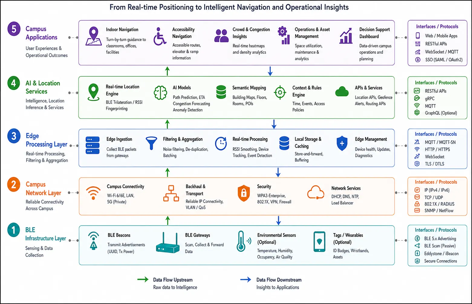
Five-layer enterprise architecture showing BLE sensing, campus networking, edge processing, AI location services, and campus applications with bidirectional data flow.
BLE Hardware, AI Software, and Deployment Options
A campus navigation solution should be engineered around the physical characteristics of each university rather than using a uniform beacon layout for every building. GAO’s BLE hardware can form part of the infrastructure used to collect and communicate location-related data across campus facilities.
BLE Beacons and BLE Sensors
Beacon selection should consider transmission power, advertising interval, battery life, mounting conditions, enclosure requirements, and maintenance accessibility. Battery-powered beacons are useful where wired power is unavailable, while powered devices may be preferable in high-traffic or permanently installed locations.
BLE sensors can extend the system beyond navigation by supplying additional contextual measurements where appropriate. Their usefulness depends on whether the resulting data contributes to a defined operational requirement.
BLE Gateways
Gateways provide an important bridge between local BLE radio communication and campus IP networks. Their placement should consider BLE coverage, network connectivity, power availability, physical security, and maintenance access.
Gateway density should not be determined solely from building size. Signal propagation, wall construction, floor separation, device density, and required location granularity can substantially change the required deployment.
AI and Location Software
The software layer may include:
- BLE data ingestion
- Device and beacon management
- Signal preprocessing
- Location estimation
- Map matching
- AI inference
- Route calculation
- Navigation APIs
- Analytics dashboards
- Alert and event processing
- System monitoring
- Data storage and reporting
The software should also expose appropriate APIs for integration with campus applications rather than requiring every application to directly process raw BLE observations.
Cloud Version
A cloud-hosted deployment is appropriate when a university wants centralized management across multiple campuses or buildings and has suitable connectivity and data-governance requirements.
Cloud deployment can simplify centralized software updates, analytics, capacity scaling, and cross-campus reporting. It can also support centralized AI model management when large datasets are used for training or analysis.
However, network dependency, data governance, latency requirements, and institutional policies must be evaluated before moving location-related processing to external infrastructure.
Server Version
A privately hosted server deployment can run on campus edge servers, customer-managed servers, private data centers, or other controlled infrastructure. This model may be preferable when the university requires greater control over data processing, network connectivity, system integration, or retention policies.
A hybrid arrangement is also possible. For example, latency-sensitive BLE processing can occur on campus while aggregated analytics or model-training workloads are handled centrally.
The deployment decision should therefore consider connectivity, privacy requirements, cybersecurity controls, existing IT infrastructure, operating responsibilities, and the expected scale of the campus navigation service.
Engineering Considerations Before Campus-Wide Deployment
Before installing BLE infrastructure across an entire university, a controlled pilot should validate radio performance, positioning behavior, map accuracy, route logic, network connectivity, battery expectations, gateway coverage, and integration requirements.
The pilot should include representative spaces such as open corridors, dense classrooms, laboratories, libraries, stairwells, elevators, large halls, and areas with challenging radio propagation.
Performance should be evaluated at actual navigation decision points rather than relying exclusively on laboratory measurements. The resulting observations can then guide beacon density, mounting locations, filtering parameters, AI model selection, and maintenance procedures.
GAO’s experience supplying BLE, RFID, and IoT hardware products and systems can support organizations evaluating the hardware and system requirements associated with these deployments. GAO is headquartered in New York City and Toronto, Canada, and has served customers across the United States and Canada, including Fortune 500 companies, research organizations, universities, and government agencies.
The next stage is to connect these technical components with measurable campus-navigation outcomes, including positioning performance, congestion management, accessibility, cybersecurity, scalability, and operational maintenance.
Technical Capabilities and Operational Benefits of AI-Powered Campus Navigation
Combining AI with BLE-based location data allows campus navigation systems to move beyond static maps and basic proximity detection. The main value comes from continuously interpreting location observations in the context of buildings, routes, pedestrian movement, accessibility requirements, and campus operations.
Improved Indoor Positioning
BLE signal measurements can fluctuate because of multipath propagation, human movement, walls, doors, furniture, and device orientation. AI-based filtering and location estimation can reduce the effect of these variations.
A model can learn recurring signal characteristics associated with specific corridors, rooms, floors, or building zones. Historical observations can also help identify persistent radio behavior that would otherwise produce inaccurate navigation results.
The practical objective is stable positioning at important decision points such as:
- Building entrances
- Corridor intersections
- Elevator and staircase areas
- Classroom wings
- Library sections
- Laboratory zones
- Accessible entrances
- Indoor-outdoor transition points
Context-Aware Route Selection
Traditional navigation commonly selects a route based primarily on distance. Campus navigation requires additional constraints.
A route engine can consider:
- Current user location
- Destination
- Building access restrictions
- Floor changes
- Elevator availability
- Accessible pathways
- Temporary closures
- Pedestrian congestion
- Event-related restrictions
- Construction zones
- Authorized areas
AI can estimate changing route conditions from historical and real-time observations, while deterministic routing rules enforce campus policies and safety constraints.
This combination is important because AI should support route optimization without overriding authoritative access, safety, or accessibility rules.
Pedestrian Flow and Congestion Analysis
Aggregated location observations can reveal recurring movement patterns across campus. AI can analyze these patterns to identify heavily used corridors, peak movement periods, building entrances with high traffic, and unusual changes in pedestrian flow.
For example, a university could use historical navigation data to identify that a particular corridor becomes heavily congested immediately before a large lecture begins. Facility or campus-operations teams could then evaluate alternative routes, signage, scheduling, or access arrangements.
Potential KPIs include:
- Average route completion time
- Navigation success rate
- Positioning error at decision points
- Route deviation rate
- Congestion duration
- Peak pedestrian density
- Average time between route recalculations
- Gateway availability
- Beacon battery life
- BLE observation success rate
- System response latency
Pedestrian Activity Across Campus Zones – Typical Academic Day
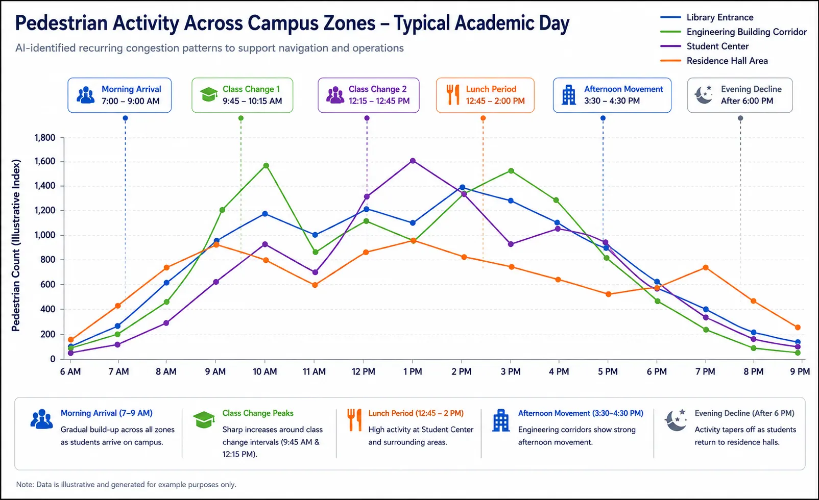
Enterprise-style AI analytics chart illustrating pedestrian activity across the library entrance, engineering building corridor, student center, and residence hall throughout a typical academic day, highlighting morning arrivals, class-change peaks, lunch activity, afternoon movement, and evening decline.
Campus Navigation Security and Data Governance
Location systems introduce cybersecurity and privacy considerations because navigation data can potentially reveal movement patterns. Security therefore needs to be designed into the system from deployment planning rather than added after installation.
BLE Infrastructure Security
BLE beacons generally transmit identifiers rather than directly carrying sensitive user information. However, the overall system can become sensitive when beacon observations are associated with identifiable devices or user accounts.
Relevant controls include:
- Secure gateway configuration
- Network segmentation
- Strong gateway authentication
- Encrypted communication between gateways and servers
- Secure API authentication
- Role-based access control
- Centralized logging
- Firmware and software update procedures
- Device inventory and lifecycle management
- Physical protection of gateways and critical infrastructure
Location Data Protection
Universities should define which location information is actually necessary for the navigation service.
Data-minimization practices can include:
- Collecting only required measurements
- Separating device identifiers from user identity where practical
- Defining retention periods
- Restricting access to operational location data
- Aggregating historical movement data when individual-level information is unnecessary
- Auditing access to sensitive records
- Establishing procedures for data deletion and incident response
The exact legal and institutional requirements depend on the jurisdiction, university policies, application design, and whether the system handles identifiable information. Security and privacy teams should therefore participate in system design before production deployment.
Interoperability with Campus IT Systems
Campus navigation rarely operates as an isolated application. Integration with existing university systems can substantially increase its operational usefulness.
Potential integration points include:
- Campus geographic information and digital maps
- Student mobile applications
- Visitor-management systems
- Room and facility management systems
- Event-management software
- Campus transportation systems
- Building management systems
- Access-control systems
- Emergency notification systems
- Business intelligence and reporting software
APIs should define consistent location identifiers, building identifiers, floor identifiers, timestamps, and device or beacon references. Map data should also have a controlled update process so that physical changes such as renovated corridors, relocated classrooms, blocked entrances, or new buildings are reflected in the navigation service.
A common deployment failure occurs when the BLE infrastructure is installed correctly but the digital map does not represent the physical environment accurately. Navigation quality depends on both the radio layer and the spatial data layer.
Deployment, Commissioning, and Maintenance
Site Survey and Planning
Deployment should begin with a detailed site survey covering building layouts, floor plans, construction materials, network connectivity, power availability, pedestrian traffic, and areas requiring high navigation accuracy.
Beacon locations should be selected based on navigation requirements rather than simply placing devices at uniform intervals.
A useful planning process identifies:
- Primary navigation decision points
- Building entrances and exits
- Staircases and elevators
- High-traffic corridors
- Accessibility routes
- Areas requiring restricted access
- Gateway mounting locations
- Network and power availability
- Areas with potential radio interference
Installation and Commissioning
After installation, each beacon and gateway should be registered with a device inventory and associated with its physical location.
Commissioning should verify:
- Beacon identifier
- Configured transmission parameters
- Battery or power status
- Gateway connectivity
- Network configuration
- Signal coverage
- Floor assignment
- Digital map association
- Positioning behavior
- Navigation route accuracy
A commissioning record should be maintained so that future maintenance teams can determine the expected configuration of each device.
Calibration and AI Model Validation
AI-based positioning models require representative data. Training or calibration data should cover different times and operating conditions because campus radio environments change throughout the day.
Testing should include:
- Different smartphone models
- Different user orientations
- Different pedestrian densities
- Open and crowded corridors
- Different floors
- Elevator and staircase transitions
- Doors open and closed
- Typical furniture configurations
- Areas with known radio interference
A model that performs well during an empty-building test may behave differently when hundreds of students occupy the same corridors.
Maintenance and Lifecycle Management
BLE infrastructure requires ongoing maintenance. Battery-powered beacons need replacement planning, while gateways and servers require software, firmware, security, and connectivity monitoring.
Useful maintenance indicators include:
- Beacon battery status
- Gateway uptime
- Missing BLE observations
- Communication failures
- Positioning error trends
- Device tampering alerts
- Software and firmware versions
- Calibration age
- Map-data synchronization status
Predictive maintenance techniques can potentially identify devices whose behavior is gradually deteriorating before they cause noticeable navigation failures.
AI and BLE for Campus Navigation – Lifecycle
Professional lifecycle timeline illustrating the end-to-end implementation of an AI and BLE campus navigation system, covering requirements assessment, site surveying, BLE hardware selection, pilot installation, commissioning, positioning calibration, AI model validation, campus integration, production rollout, performance monitoring, maintenance, and periodic optimization. It also highlights representative campus environments and technical checkpoints at each stage.
Scalability Across Buildings and Campuses
A campus navigation deployment should be designed so that additional buildings can be incorporated without redesigning the entire system.
A scalable implementation should maintain standardized identifiers for:
- Campuses
- Buildings
- Floors
- Zones
- Beacons
- Gateways
- Navigation nodes
- Routes
- Accessibility attributes
The software should also separate building-specific configuration from common navigation logic. This allows a university to add a new academic building while retaining the same core services for location processing, analytics, authentication, and monitoring.
Multi-campus universities can use centralized management while retaining local edge processing where network latency or data-governance requirements justify it.
AI model management should also account for differences between buildings. A model calibrated for a modern concrete-and-glass building may not perform identically in an older structure with different wall materials and floor layouts.
Common Campus Navigation Bottlenecks and Engineering Responses
Unstable RSSI Measurements
RSSI can vary even when a receiver remains in approximately the same location.
Engineering response: combine signal filtering, multiple observations, calibrated fingerprints, map constraints, and movement context instead of relying on a single RSSI measurement.
Incorrect Floor Detection
Signals can propagate between floors, causing a receiver to associate with beacons belonging to another floor.
Engineering response: incorporate floor-specific beacon layouts, vertical-transition logic, barometric or device information where available, and map constraints.
Physical Map Changes
Construction, room reassignment, temporary closures, and relocated entrances can make navigation instructions incorrect.
Engineering response: establish ownership for digital-map updates and connect facility-management processes with navigation data wherever practical.
Battery Depletion
A beacon with a depleted battery can create a localized positioning problem that may not be immediately obvious.
Engineering response: monitor battery telemetry where supported, maintain device inventories, establish replacement thresholds, and prioritize high-dependency navigation points.
Network Outages
Gateway connectivity interruptions can prevent observations from reaching centralized software.
Engineering response: use local buffering, health monitoring, redundant connectivity where justified, and defined degraded-operation behavior.
Overreliance on AI
An AI model can produce incorrect predictions when conditions differ from its training data.
Engineering response: combine AI with deterministic map constraints, validated routing rules, confidence thresholds, monitoring, and fallback positioning methods.
Measuring Campus Navigation Performance
A production system should use measurable acceptance criteria rather than relying on subjective impressions.
Important technical and operational measurements can include:
- Positioning accuracy by building and floor
- Decision-point accuracy
- Route completion percentage
- Route recalculation frequency
- Average navigation latency
- Gateway availability
- BLE beacon availability
- Battery replacement interval
- API response time
- Map synchronization accuracy
- Congestion prediction performance
- AI model confidence and error rates
- Accessibility route success rate
- User-reported navigation failures
Performance should also be segmented by environment. Reporting one campus-wide accuracy number can hide problems concentrated in particular buildings, floors, corridors, or navigation scenarios.
Implementation Recommendations for AI-Powered Campus Navigation
Successful campus navigation deployments generally benefit from a phased implementation rather than immediate campus-wide installation.
Recommended engineering priorities include:
- Define navigation use cases and measurable acceptance criteria before selecting hardware.
- Survey representative buildings before finalizing beacon density and gateway locations.
- Treat digital campus maps as a core technical dependency.
- Pilot BLE positioning in buildings with different construction characteristics.
- Validate performance at navigation decision points.
- Use AI where it addresses measurable positioning, routing, prediction, or anomaly-detection problems.
- Retain deterministic safety and access rules around AI-driven recommendations.
- Establish cybersecurity controls for gateways, servers, APIs, and administrative interfaces.
- Define location-data governance, retention, and access policies.
- Integrate navigation data with relevant campus software through controlled interfaces.
- Monitor beacon health, gateway availability, positioning accuracy, and map consistency after commissioning.
- Design device replacement, battery management, calibration, and software updates into the operating model.
- Expand building by building after the pilot meets predefined technical and operational targets.
Building Practical AI and BLE Campus Navigation Systems with GAO
AI-powered campus navigation is most effective when positioning data, BLE infrastructure, digital maps, AI processing, routing logic, and campus operations are engineered as one coordinated system. BLE beacons, gateways, and sensors provide the physical data layer, while AI can improve signal interpretation, movement analysis, congestion prediction, and context-aware navigation.
GAO has invested in R&D for BLE, RFID, and IoT products and systems for more than three decades. GAO, together with GAO Research and GAO Tek, serves organizations in the United States and Canada, including universities, research organizations, government agencies, and major businesses. The companies maintain operations in New York City and Toronto, Canada, and emphasize product quality, technical support, and engineering assistance.
Organizations planning indoor campus positioning, BLE navigation, location intelligence, or related IoT deployments can evaluate their requirements with GAO’s technical team and explore suitable hardware products and system solutions.
Building the Future of Industrial AI and IoT with Aperture Venture Studio and GAO
For more than three decades, GAO Group of Companies has invested heavily in R&D for industrial BLE, RFID, and IoT. As generative AI has become increasingly useful for industrial applications, we have expanded our work across AI and IoT technologies, including BLE and RFID, and founded Aperture Venture Studio to help develop and scale AI and IoT solutions relevant to applications such as campus navigation and location intelligence.
Aperture has attracted AI and IoT technical experts, operational executives, investors, and leading companies. We have also developed Aperture Ventures Summit and TekSummit to facilitate discussion of advanced AI and IoT topics.
We welcome advisors, co-founders, employees, investors, and customers to participate in these initiatives and technical communities.