
AI and BLE for Smart Wayfinding
How AI and BLE Improve Smart Wayfinding
AI and BLE can provide a practical foundation for smart wayfinding systems that help people navigate complex indoor and mixed indoor-outdoor environments. BLE beacons transmit location signals that smartphones, mobile applications, dedicated receivers, or BLE gateways can detect. AI software can then use positioning data, movement patterns, destination information, facility maps, and operational data to improve route recommendations and identify conditions that affect navigation.
Smart wayfinding is particularly relevant to hospitals, airports, universities, corporate facilities, shopping centers, transportation terminals, convention centers, museums, industrial campuses, and other large properties where conventional signs may not provide sufficient location context. BLE provides relatively low-power location signaling, while AI can analyze positioning events and operational conditions to support dynamic routing, congestion analysis, accessibility-aware navigation, and facility management.
GAO supplies BLE beacons, BLE gateways, BLE sensors, and related IoT hardware that can be incorporated into smart wayfinding systems. These components can provide the location and environmental data required by software applications and AI analytics.
AI and BLE Smart Wayfinding System Architecture
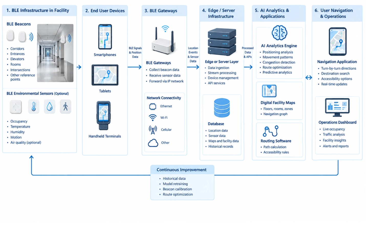
This diagram shows how BLE beacons and optional sensors provide location data to gateways, edge/server infrastructure, AI analytics, digital maps, routing software, and navigation applications. A continuous-improvement loop supports beacon calibration, model retraining, and route optimization.
Smart Wayfinding Technology Fundamentals
Smart wayfinding combines location detection, digital mapping, routing logic, mobile interfaces, wireless communication, and analytics. BLE is useful because beacons can periodically transmit identifiers that allow compatible receivers to estimate proximity or contribute to a positioning calculation.
A typical deployment contains several technical layers:
- BLE beacons: Fixed transmitters positioned at known coordinates throughout a facility.
- BLE gateways: Network-connected devices that collect BLE advertisements or sensor information and forward events to processing systems.
- BLE sensors: Devices capable of supplying additional information such as occupancy-related signals, temperature, motion, or other environmental conditions where applicable.
- Mobile devices: Smartphones, tablets, handheld terminals, or specialized devices that interact with BLE signals and wayfinding applications.
- Digital maps: Structured representations of buildings, floors, rooms, corridors, entrances, exits, elevators, stairways, restricted areas, and accessible routes.
- Positioning software: Software that converts BLE observations into estimated locations or proximity information.
- AI analytics: Machine-learning or statistical models that analyze movement, positioning, congestion, and historical navigation data.
- Routing software: Software that calculates paths based on destination, facility topology, restrictions, and user requirements.
- Enterprise systems: Facility management, building management, visitor management, transportation, healthcare, or other operational software that may provide contextual information.
BLE positioning should not automatically be treated as equivalent to high-precision survey-grade positioning. Accuracy depends on beacon density, antenna characteristics, radio propagation, mounting position, interference, floor construction, metal structures, device orientation, calibration, and the positioning method used.
This distinction is important when designing smart wayfinding for large facilities. A system intended to identify the nearest building entrance has different accuracy requirements from one intended to guide a user through a specific hospital corridor.
AI and BLE Applications for Smart Wayfinding
Indoor Navigation
Indoor navigation is one of the most direct applications of BLE-based wayfinding. GPS signals are often unreliable or unavailable inside buildings, while BLE beacons can establish known radio reference points.
A mobile application can observe nearby beacon identifiers and use their relative signal characteristics to estimate the user’s position. Routing software can then calculate a path through a digital map.
AI can improve this process by analyzing historical positioning observations and identifying systematic errors caused by building layout, radio propagation, device behavior, or frequently traveled routes.
For example, if a particular corridor consistently produces location estimates several meters away from the user’s actual position, historical observations can help identify the discrepancy and support calibration adjustments.
Accessibility-Aware Routing
Smart wayfinding can incorporate accessibility requirements into route calculation. Digital maps can identify elevators, ramps, accessible entrances, automatic doors, and other relevant infrastructure.
The routing system can exclude stairways when an accessible route is required and calculate an alternative path through elevators or ramps.
AI can further analyze route usage and operational conditions to identify recurring accessibility bottlenecks. For example, repeated navigation delays near an elevator may indicate congestion or an operational issue requiring facility attention.
Airport and Transportation Terminal Wayfinding
Airports and transportation terminals contain multiple floors, gates, security checkpoints, retail areas, lounges, baggage facilities, elevators, and controlled-access zones. A static sign system cannot always account for changing operational conditions.
BLE can provide location references throughout terminal areas. AI software can combine location observations with operational information to support route recommendations.
Potential applications include:
- Gate-to-gate navigation
- Checkpoint routing
- Baggage claim navigation
- Parking-to-terminal guidance
- Accessible route calculation
- Retail and facility location
- Congestion analysis
- Passenger movement analysis
- Dynamic route recommendations
The system should distinguish between navigation information and authoritative operational instructions. For example, flight gate changes should originate from the appropriate operational system rather than being inferred solely from BLE positioning data.
Hospital and Healthcare Facility Navigation
Large hospitals often contain multiple buildings, floors, departments, clinics, laboratories, imaging areas, pharmacies, elevators, waiting areas, and restricted zones.
BLE can help establish indoor location references for patients, visitors, staff, and authorized mobile devices. A wayfinding application can use these references to guide users toward departments and facilities.
AI can analyze anonymized movement patterns to identify frequently confusing intersections, high-delay routes, or areas where users repeatedly deviate from recommended paths.
Healthcare deployments require careful consideration of privacy, device authorization, data retention, and access control. Wayfinding analytics should also remain separate from clinical decision-making systems unless a specific, validated integration is required.
University and Campus Wayfinding
University campuses frequently combine indoor buildings with outdoor pedestrian routes. BLE beacons can provide location references inside buildings, while other positioning technologies can support outdoor navigation.
A unified routing system can represent:
- Academic buildings
- Lecture halls
- Laboratories
- Libraries
- Student services
- Parking areas
- Pedestrian paths
- Accessible entrances
- Elevators
- Restricted areas
AI can analyze navigation demand by building, time period, event schedule, or campus area to help identify recurring congestion and routing problems.
Smart Wayfinding Operational Workflow
A technically effective smart wayfinding solution requires more than installing BLE beacons. The complete workflow extends from physical site assessment and radio deployment through positioning, map management, routing, analytics, and operational feedback.
Location Data Acquisition
The process begins with BLE beacons positioned at known reference coordinates. Beacon identifiers, installation coordinates, floor information, transmission parameters, and other configuration attributes should be recorded in an asset database.
Beacon placement should consider:
- Building materials
- Floor-to-floor separation
- Metal structures
- HVAC equipment
- Electrical infrastructure
- Human traffic density
- Corridor geometry
- Elevator areas
- Stairwells
- Signal obstruction
- Required positioning accuracy
A site survey should precede large-scale installation because theoretical beacon spacing does not guarantee predictable radio behavior.
BLE Communication and Gateway Collection
BLE devices transmit advertising packets over the BLE radio interface. Depending on the deployment design, smartphones may directly scan beacon signals, or BLE gateways may collect BLE observations and forward them through an IP network.
Gateway connectivity can use Ethernet, Wi-Fi, cellular connectivity, or other appropriate network infrastructure.
Where gateways are used, the data path may resemble:
BLE Beacon → BLE Gateway → IP Network → Edge or Server Processing → Location Database → AI Analytics → Routing Application
Protocols such as MQTT can be used for telemetry-oriented communication where appropriate. REST APIs or other application interfaces can connect location services with facility applications.
Position Estimation and Map Matching
Raw BLE observations do not automatically represent a usable navigation coordinate. The software must interpret the observed beacon information and determine an estimated position.
Possible approaches include:
- RSSI-based proximity estimation
- Fingerprinting
- Trilateration or multilateration
- Zone-based positioning
- Sensor-assisted positioning
- Map matching
- Hybrid positioning
RSSI-based positioning can be affected by reflections and obstructions. Fingerprinting can improve location estimation in environments where radio characteristics are relatively stable, but it requires site-specific calibration data.
Map matching can constrain estimated positions to valid corridors, rooms, paths, or other mapped areas. This prevents a navigation application from producing physically impossible routes.
Smart Wayfinding Operational Workflow with AI and BLE
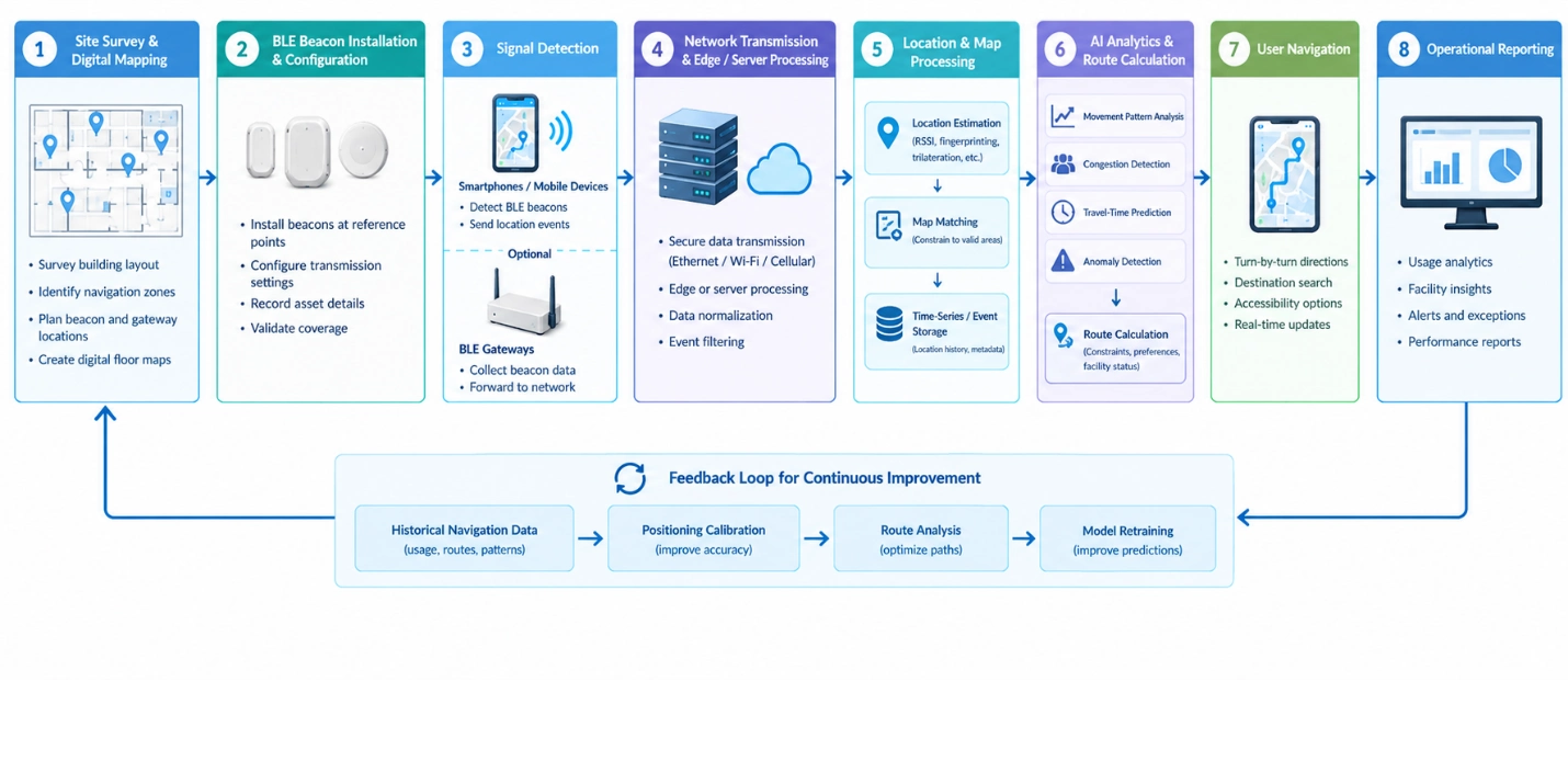
The completed workflow illustrates how smart wayfinding progresses from site surveying and BLE beacon deployment through signal detection, location processing, AI route calculation, navigation, and operational reporting. A feedback loop connects historical navigation data with positioning calibration, route analysis, and model retraining.
AI Analytics and Route Optimization
AI can operate on historical and real-time location data to identify patterns that conventional rule-based routing may not detect efficiently.
Relevant AI functions include:
- Location anomaly detection
- Movement-pattern analysis
- Congestion prediction
- Route demand forecasting
- Positioning error analysis
- Travel-time estimation
- Destination demand prediction
- Path deviation analysis
- Facility bottleneck identification
AI should complement deterministic routing rules rather than replace them indiscriminately. Safety restrictions, access-control boundaries, emergency exits, restricted areas, and physical building constraints should be represented explicitly in the digital map and routing logic.
BLE Hardware and Supporting Software
A smart wayfinding deployment typically requires coordinated hardware, communication infrastructure, software, and data management.
BLE Beacons
BLE beacons are normally installed at fixed and documented locations. Each beacon should have a unique identifier associated with a physical coordinate or zone.
Installation records should include:
- Beacon ID
- Building
- Floor
- Room or zone
- Latitude and longitude where applicable
- Indoor X/Y coordinates
- Mounting height
- Transmission power
- Advertising interval
- Battery status
- Installation date
- Maintenance status
Battery-powered beacons require an appropriate maintenance strategy because depleted batteries can create navigation gaps.
BLE Gateways
BLE gateways are useful when a deployment requires centralized collection of BLE observations or sensor data. Gateways bridge BLE wireless communications and IP-based networks.
Industrial or commercial installations should consider gateway coverage, Ethernet availability, Wi-Fi reliability, network segmentation, power availability, physical security, and firmware management.
GAO provides BLE gateways and related BLE hardware that can be used as components of location and IoT deployments.
BLE Sensors
BLE sensors can extend smart wayfinding beyond basic positioning. Depending on the application, sensors may provide environmental or operational information that can contribute to facility analytics.
Examples include temperature, humidity, motion, door-state, and other sensor measurements.
These measurements should only influence routing when their relationship to navigation is explicitly defined. For example, a facility system might use operational data to identify an inaccessible route, while the routing engine continues to enforce predefined safety and accessibility rules.
Digital Mapping and Location Databases
Digital mapping is a core component of smart wayfinding. A floor map should represent navigable areas rather than simply display a visual floor plan.
A routing graph can contain nodes and edges representing:
- Corridors
- Intersections
- Rooms
- Doors
- Elevators
- Stairways
- Ramps
- Entrances
- Exits
- Restricted zones
This structured representation allows routing software to calculate valid paths and apply constraints.
Cloud Version and Server Version for Smart Wayfinding
Smart wayfinding can be implemented using cloud-hosted software or privately managed server infrastructure. The appropriate choice depends on data governance, connectivity, facility size, integration requirements, and operational policies.
Cloud Version
A cloud deployment can host location processing, databases, analytics, APIs, dashboards, and application services in cloud infrastructure.
This model can be useful when:
- Multiple facilities need centralized management
- Sites are geographically distributed
- Remote software administration is important
- Large-scale analytics are required
- Centralized data aggregation is desirable
- Internet connectivity is reliable
Cloud deployment can simplify centralized software updates and provide scalable computing resources. However, network dependency must be considered. A facility requiring continued local navigation during an internet outage may need local processing or cached map and routing data.
Server Version
A server deployment can place the smart wayfinding software on customer-managed servers, private data centers, facility servers, or edge computing infrastructure.
This model can be appropriate when:
- Location data must remain within controlled infrastructure
- Internet connectivity is limited
- Local processing is required
- Existing IT infrastructure must be reused
- Data governance requirements favor private deployment
- Low-latency local processing is important
A hybrid design is also possible. Local servers can perform positioning and routing while selected analytics are transferred to a centralized environment.
Key Technical Capabilities of AI and BLE Smart Wayfinding
Combining AI with BLE allows smart wayfinding systems to move beyond static location markers and basic point-to-point navigation. BLE provides the wireless observations needed to establish location context, while software and AI can interpret those observations against facility maps, historical movement patterns, and operational conditions.
Improved Indoor Positioning
BLE provides a practical positioning reference where satellite-based positioning is unavailable or unreliable. Proper beacon placement and calibration can establish useful location zones throughout buildings.
AI can further improve positioning by learning recurring signal behavior. Historical RSSI observations, known beacon locations, device characteristics, and map constraints can be used to identify positioning errors and improve estimated locations.
The resulting performance depends heavily on the physical environment. Dense concrete structures, elevators, metal equipment, glass partitions, people, and other radio-reflective or obstructive materials can affect BLE propagation. Engineering validation should therefore be performed at representative locations rather than relying solely on laboratory measurements.
Dynamic Route Selection
A conventional route engine can calculate the shortest or fastest path from one mapped location to another. AI can add contextual information such as historical travel times, congestion patterns, and frequently selected routes.
For example, a large convention center may have several routes between two halls. If one corridor consistently becomes congested during scheduled events, analytics can identify that pattern and support alternative routing.
Routing decisions should remain governed by explicit facility constraints. AI-generated recommendations should not override restricted zones, emergency exits, accessibility requirements, or other predefined operational rules.
Congestion and Movement Analysis
Aggregated BLE positioning events can provide information about movement through corridors, entrances, elevators, waiting areas, and other zones.
AI models can analyze this information to identify:
- Frequently congested corridors
- High-demand entrances
- Elevator bottlenecks
- Unusually long travel times
- Repeated route deviations
- Areas with high navigation demand
- Changes in movement patterns
- Underutilized routes
This information can support facility planning as well as wayfinding improvements.
Context-Aware Navigation
Smart wayfinding can incorporate contextual information from facility systems. A route may need to change because of temporary construction, restricted access, elevator availability, maintenance activity, or an event-related traffic pattern.
The routing system should receive authoritative status information from the relevant facility system whenever possible.
AI can analyze these inputs and help identify alternative paths, but the underlying route constraints should remain explicit and auditable.
Enterprise System Integration for Smart Wayfinding
Smart wayfinding becomes more useful when location information can interact with existing facility and operational software.
Potential integration points include:
- Building management systems
- Facility management systems
- Visitor management software
- Mobile applications
- Digital signage systems
- Access-control systems
- Event management software
- Hospital information systems
- Airport operational systems
- Campus management systems
- Computerized maintenance management systems
- Geographic information systems
APIs can transfer location events and route information between the smart wayfinding software and these systems.
For example, a facility management system may identify that an elevator is unavailable. The wayfinding system can consume that status and remove the elevator from eligible routes.
A visitor management application could provide the destination while the wayfinding software calculates an appropriate path based on the visitor’s current location.
Integration should be designed around clearly defined data ownership. A navigation system should not become the authoritative source for operational information that belongs to another enterprise application.
AI Models and Analytics for Smart Wayfinding
Different AI techniques can support different smart wayfinding requirements.
Positioning Error Detection
Machine-learning models can identify unusual relationships between observed BLE signals and expected locations.
For example, if a beacon that normally has strong observations within a specific zone suddenly appears consistently in a distant zone, the system can flag the observation for investigation.
Potential causes include:
- Beacon displacement
- Battery degradation
- Hardware failure
- Changed transmission settings
- New physical obstructions
- Radio interference
- Gateway configuration problems
Travel-Time Prediction
Historical movement data can support travel-time estimation between mapped locations.
A model can consider:
- Time of day
- Day of week
- Facility occupancy
- Historical movement
- Event schedules
- Route characteristics
- Elevator usage
- Known temporary restrictions
Predicted travel time can then become an input to route selection.
Anomaly Detection
Anomaly detection can identify changes in normal movement patterns.
Examples include unusually high traffic in an area, sudden disappearance of BLE observations, abnormal gateway behavior, or unexpected route deviations.
These analytics should generate operational alerts for investigation rather than automatically assuming that every anomaly represents a physical emergency.
Demand Forecasting
Historical wayfinding activity can help estimate future demand across facilities.
Facility managers can use this information to plan staffing, signage, temporary route changes, event management, and maintenance activities.
Security and Data Protection
Security should be incorporated throughout a BLE smart wayfinding deployment rather than treated as a final implementation step.
BLE devices, gateways, networks, servers, databases, APIs, mobile applications, and administrative interfaces each introduce different security considerations.
Important controls include:
- Unique device identification
- Secure gateway configuration
- Network segmentation
- Role-based access control
- Authentication for administrative interfaces
- Encrypted IP communications
- Secure API authentication
- Firmware management
- Logging and audit trails
- Credential rotation
- Database access controls
- Data retention policies
- Monitoring for unauthorized devices
BLE beacon identifiers themselves generally do not provide strong authentication of a user’s identity. Therefore, system designers should avoid treating the detection of a particular beacon signal as proof of user identity.
Where smart wayfinding collects information associated with identifiable individuals, privacy requirements become particularly important. Data minimization, appropriate retention periods, access controls, and anonymization or aggregation should be considered according to the application’s requirements and applicable regulations.
For healthcare, transportation, and other sensitive environments, security requirements should be established during system design and validated during commissioning.
Deployment Engineering Considerations
Successful smart wayfinding depends heavily on installation quality and commissioning.
Site Survey and Beacon Placement
Beacon locations should be selected using both the digital map and physical radio environment.
The engineering team should document:
- Building geometry
- Floor boundaries
- Corridor dimensions
- Beacon mounting locations
- Gateway locations
- Network connections
- Power availability
- Radio interference sources
- Required positioning accuracy
Beacon density should be based on the required positioning performance rather than an arbitrary spacing rule.
Calibration
A deployment should undergo calibration after physical installation.
Calibration can include collecting BLE observations at known coordinates and comparing estimated positions against reference locations.
This process can reveal:
- Signal attenuation
- Unexpected multipath effects
- Weak coverage areas
- Beacon overlap
- Positioning errors
- Gateway coverage gaps
The calibration dataset can also become a useful foundation for AI-based positioning improvement.
Commissioning and Testing
Commissioning should verify the complete data path rather than testing beacons individually.
Testing should cover:
- Beacon transmission
- Gateway BLE reception
- IP network connectivity
- Data ingestion
- Database recording
- Position calculation
- Map matching
- Route calculation
- Mobile application behavior
- API integration
- Alert generation
- Administrative access
- Failure recovery
A useful acceptance test should include real movement through representative corridors, intersections, elevators, entrances, and other challenging areas.
KPIs for AI and BLE Smart Wayfinding
Performance measurement should combine technical, navigation, and operational indicators.
Useful KPIs include:
| KPI | What It Measures |
|---|---|
| Positioning accuracy | Difference between estimated and reference location |
| Route completion rate | Percentage of navigation sessions reaching the intended destination |
| Route deviation rate | Frequency of users departing from recommended paths |
| Average navigation time | Time required to reach destinations |
| Position update latency | Delay between BLE observation and location availability |
| Beacon availability | Percentage of deployed beacons operating normally |
| Gateway availability | Availability of BLE-to-IP collection infrastructure |
| Signal coverage | Percentage of required areas with usable BLE observations |
| Route recalculation time | Time required to produce an updated route |
| Navigation error rate | Frequency of incorrect or unusable navigation results |
| Congestion detection accuracy | Performance of congestion identification |
| Battery status compliance | Percentage of battery-powered BLE devices within acceptable levels |
| System uptime | Availability of the complete wayfinding service |
| API availability | Reliability of integrations with external systems |
KPI thresholds should be defined according to the specific facility and use case. A visitor-navigation system may tolerate different positioning performance from a specialized operational tracking application.
Practical Implementation Recommendations
A phased implementation can reduce technical risk and provide measurable validation before a large facility-wide rollout.
Start With a Defined Navigation Use Case
Select a specific navigation problem before installing hardware.
Examples include:
- Visitor navigation between departments
- Airport terminal navigation
- Accessible route guidance
- Campus building navigation
- Convention center navigation
- Indoor facility directory navigation
The use case determines the required positioning accuracy, map detail, BLE density, application behavior, and integration requirements.
Build the Digital Map Before Full Deployment
The routing model should represent the physical environment accurately before large-scale BLE installation.
Doors, corridors, stairs, elevators, restricted areas, entrances, exits, and accessible paths should be represented as structured navigation elements.
Pilot in a Representative Area
A pilot should include technically difficult areas rather than only open corridors.
Good pilot locations include:
- Elevator lobbies
- Intersections
- Dense public areas
- Concrete structures
- Areas with metal infrastructure
- Multiple-floor transitions
- Accessible routes
- High-traffic entrances
This exposes positioning and routing problems before they become facility-wide issues.
Separate Positioning From Operational Decisions
BLE should provide location observations. The software should transform those observations into useful navigation information.
AI should support analysis, prediction, and optimization while explicit business and safety rules control critical routing constraints.
This separation improves system explainability and makes troubleshooting easier.
Establish a Maintenance Process
BLE infrastructure is a physical asset and therefore requires ongoing maintenance.
Maintenance procedures should address:
- Battery replacement
- Beacon displacement
- Gateway failures
- Network outages
- Firmware updates
- Map changes
- Building renovations
- New restricted areas
- Changed accessibility routes
- Calibration updates
Facility modifications can change radio behavior, so major renovations should trigger a positioning validation process.
Scaling AI and BLE Smart Wayfinding Across Facilities
Scaling from one building to multiple locations requires standardized device management, map structures, configuration practices, APIs, and operational procedures.
A multi-site deployment should maintain clear relationships among:
Organization → Facility → Building → Floor → Zone → Beacon/Gateway → Location Data → Navigation Service
Each physical BLE device should have a unique identity and documented installation location.
Centralized software can aggregate analytics across facilities while retaining facility-specific maps and routing constraints.
AI models may also require site-specific calibration. Radio behavior differs between a hospital, airport, university, warehouse, and office building. A model trained in one facility should not automatically be assumed to perform identically in another.
GAO’s experience supplying BLE hardware and IoT systems to organizations in the United States and Canada provides a practical foundation for deployments where hardware selection, installation, connectivity, and system integration must work together.
Key Takeaways for Smart Wayfinding Deployment
AI and BLE provide complementary capabilities for smart wayfinding. BLE supplies wireless location references, while AI and analytics can improve positioning analysis, travel-time estimation, congestion detection, route optimization, and facility insight.
The most important implementation considerations include:
- Perform a physical BLE site survey before large-scale deployment.
- Build an accurate digital navigation map.
- Select beacon density according to required positioning performance.
- Validate positioning in difficult radio environments.
- Use gateways where centralized BLE data collection is required.
- Separate navigation constraints from AI-generated recommendations.
- Integrate authoritative facility status information through defined APIs.
- Apply security controls to devices, gateways, networks, servers, and applications.
- Measure positioning, routing, infrastructure, and operational KPIs.
- Establish maintenance procedures for both BLE hardware and digital maps.
- Validate AI models using facility-specific data before operational use.
- Select cloud, server, or hybrid deployment according to connectivity, governance, scalability, and local-processing requirements.
GAO provides BLE beacons, gateways, sensors, and related IoT hardware that can support these technical requirements. Organizations planning smart wayfinding can evaluate hardware specifications, positioning requirements, gateway coverage, network connectivity, software integration, and deployment support before selecting a final system design.
Building the Future of Industrial AI and IoT with Aperture Venture Studio and GAO RFID Inc.
For more than three decades, GAO Group of Companies has invested heavily in R&D involving BLE, RFID, IoT, and related technologies. As AI has become increasingly useful for practical applications, our work has expanded toward combining AI with connected sensing and location technologies. We have also established Aperture Venture Studio to support the development and scaling of AI and IoT technologies relevant to areas such as smart wayfinding and location-based services.
Aperture brings together technical specialists, executives, investors, and technology organizations. GAO Group has also developed industry events including Aperture Ventures Summit and TekSummit to discuss advanced AI and IoT topics.
GAO RFID Inc., GAO Research Inc., and GAO Tek Inc. form GAO Group, with operations based in New York City and Toronto, Canada. For three decades, GAO Group has served organizations across the United States and Canada, including Fortune 500 companies, R&D organizations, universities, and government agencies. Our work includes supplying BLE, RFID, and IoT hardware products and systems with stringent quality assurance and technical support.