
AI and BLE for Indoor Navigation
AI-Powered Indoor Navigation for Positioning and Location-Based Services
Indoor navigation uses location data, digital maps, and positioning technologies to guide people, locate assets, and improve movement visibility where GPS is unreliable or unavailable. AI makes these systems more useful by converting continuous location data into operational insights, such as identifying congestion, predicting movement patterns, detecting abnormal routes, and improving wayfinding decisions. BLE beacons, gateways, and sensors provide practical data acquisition for indoor environments because Bluetooth Low Energy can support battery-powered devices and location-aware applications across facilities such as hospitals, airports, warehouses, manufacturing plants, campuses, retail facilities, and large commercial buildings. AI and BLE for Indoor Navigation therefore combines positioning data with machine learning, edge processing, mapping software, and enterprise applications. GAO supplies BLE hardware products and IoT systems that organizations can integrate into indoor positioning solutions where reliable location visibility is required.
H2: AI-Driven Indoor Navigation Architecture Using BLE, AI, and Digital Maps
This architecture diagram illustrates how BLE beacons and sensors feed location data through gateways, edge processing, AI positioning models, and digital indoor maps. It highlights applications including indoor wayfinding, asset tracking, congestion analytics, emergency response, and operational analytics, along with integration into enterprise systems.
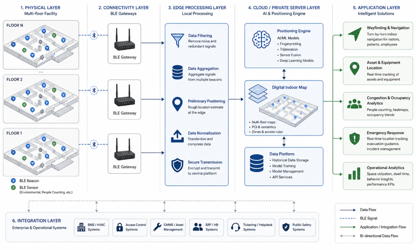
How AI Improves Indoor Navigation and Indoor Positioning
Indoor navigation becomes substantially more useful when positioning data is treated as an operational data source rather than simply a mechanism for displaying a user’s location on a map. Traditional indoor positioning can determine approximate coordinates from signal measurements, while AI can analyze historical and real-time observations to improve location estimates and interpret what is happening within a facility.
BLE provides the underlying radio observations through beacons, gateways, and sensors. Depending on the deployment, systems can use received signal strength indication (RSSI), beacon identifiers, gateway observations, device telemetry, and other contextual data. Positioning software can combine these observations with floor plans, zones, access points, known reference locations, and movement constraints.
AI methods can then address problems that are difficult to solve with fixed rules alone. Machine learning models can learn signal behavior in specific buildings, while filtering techniques can reduce position instability caused by multipath propagation, human obstruction, reflective surfaces, device orientation, and changing environmental conditions. Predictive models can also estimate movement trends, identify abnormal dwell times, and support congestion-aware routing.
The result is more than a blue dot on a digital floor plan. An AI-enabled indoor navigation solution can help a hospital understand movement between departments, help a warehouse direct personnel toward designated zones, help an airport analyze passenger flows, or help a manufacturing facility identify inefficient movement around production areas.
GAO’s BLE products can serve as the sensing and communication layer within these deployments, while AI, positioning software, digital maps, and business applications provide the higher-level operational functions.
Indoor Navigation Use Cases That Benefit from AI
The most valuable applications depend on the facility’s movement patterns, positioning accuracy requirements, available infrastructure, and operational objectives.
- AI indoor wayfinding: AI can help select routes based on current congestion, restricted areas, temporary closures, accessibility requirements, or changing facility conditions rather than relying exclusively on static routes.
- Hospital indoor navigation: Location-aware applications can guide visitors and staff between departments while supporting location visibility for mobile equipment, service teams, and selected operational workflows.
- Warehouse navigation: Indoor positioning can support worker navigation between storage, picking, packing, staging, and shipping areas while providing movement data for process analysis.
- Manufacturing facility navigation: Location information can help personnel navigate production areas, maintenance zones, tool rooms, inspection stations, and restricted areas.
- Airport and transportation facility navigation: Indoor positioning can support passenger wayfinding, terminal navigation, service-area visibility, and analysis of movement through high-traffic zones.
- Campus and large-building navigation: AI can use location patterns to improve route recommendations across buildings, floors, corridors, entrances, elevators, and other designated areas.
- Emergency and evacuation support: Location information can provide situational awareness during incidents, while routing logic can account for blocked corridors, restricted zones, and designated exits when the underlying emergency system provides the necessary information.
AI Indoor Navigation Use Cases Across Hospitals, Warehouses, Airports, and Commercial Facilities
This infographic compares how AI-driven indoor navigation supports six facility types: hospitals, warehouses, manufacturing plants, airports, university campuses, and large commercial buildings. It highlights indoor positioning, AI route optimization, congestion analysis, asset and personnel visibility, and operational decision support, with a workflow showing how BLE data moves through gateways, edge processing, AI analytics, and applications.
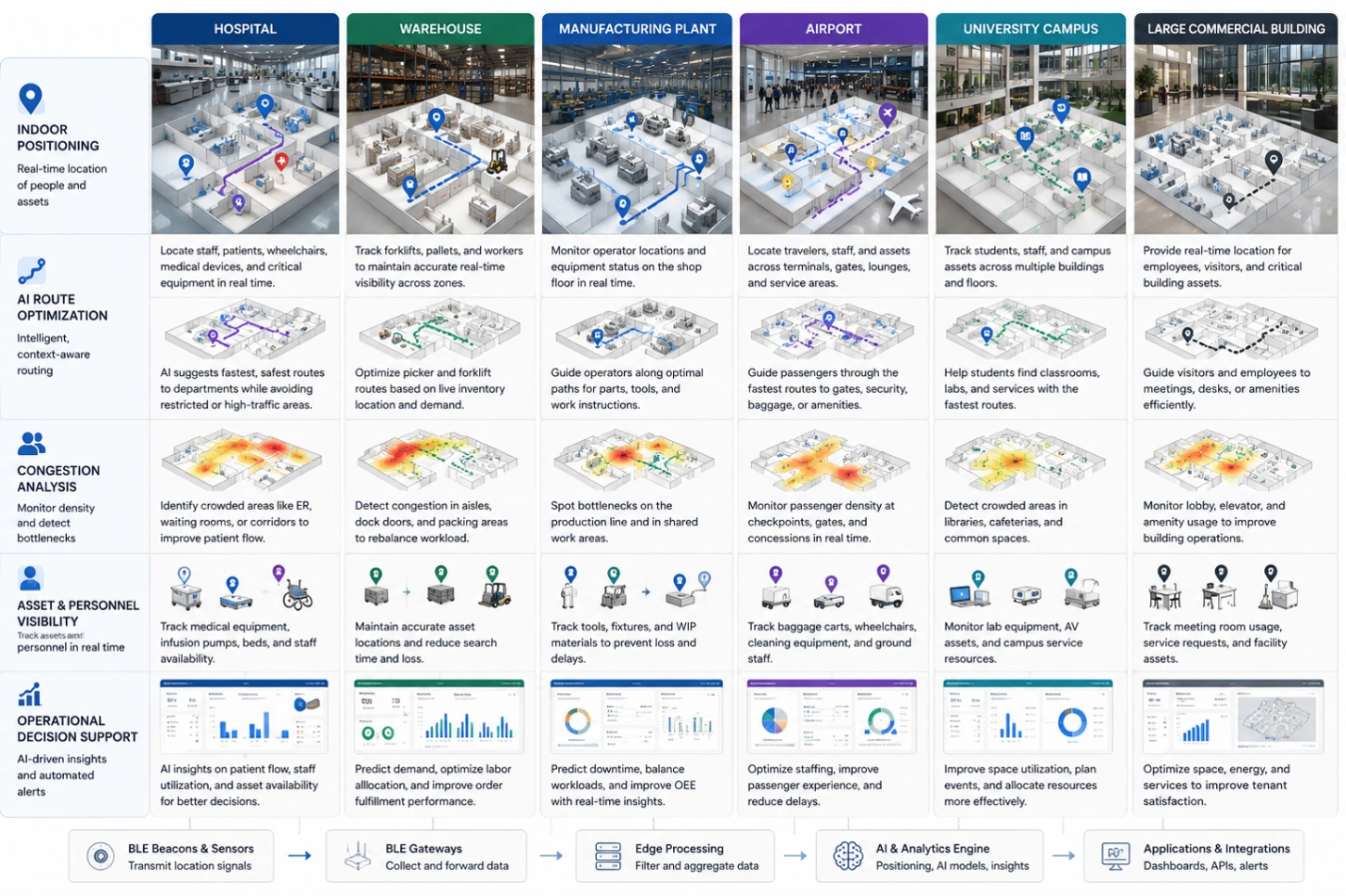
Indoor Positioning Data and AI Decision-Making
A practical AI indoor navigation solution begins with reliable location observations. Data quality determines how effectively downstream algorithms can estimate position and make operational recommendations. BLE deployments therefore require more than installing transmitters throughout a building. Engineers must determine where location observations are required, how frequently they should be collected, how the signal environment affects accuracy, and how the resulting data will be integrated with facility maps and operational software.
From BLE Signal Acquisition to Location Intelligence
A typical workflow can be divided into several connected stages:
- Data acquisition: BLE beacons transmit identifiers and signals, while BLE sensors can provide contextual telemetry. Gateways collect observations from devices within their coverage areas.
- Communication: Gateway connectivity can use Ethernet, Wi-Fi, cellular connectivity, or another suitable IP network depending on the facility and deployment constraints.
- Edge processing: Local processing can normalize observations, remove invalid readings, apply basic filtering, buffer data during connectivity interruptions, and reduce unnecessary transmission.
- Position estimation: Positioning software converts signal observations into estimated locations or zones using methods such as RSSI-based estimation, fingerprinting, proximity detection, trilateration-related techniques, or hybrid positioning methods.
- AI processing: Machine learning models can improve location estimates, identify recurring movement patterns, detect anomalies, estimate congestion, or predict likely movement behavior.
- Digital map integration: Coordinates must correspond to meaningful indoor spaces, including rooms, corridors, storage locations, production areas, entrances, elevators, stairs, restricted zones, and emergency exits.
- Enterprise software integration: Location events can be transferred to workforce applications, warehouse management systems, facility management software, hospital systems, transportation applications, security systems, dashboards, or custom operational software.
- Operational action: The resulting information can trigger route changes, task assignments, alerts, maintenance actions, congestion responses, or other decisions defined by the facility’s operating procedures.
This workflow highlights an important engineering principle: AI cannot compensate indefinitely for poor positioning data. Beacon placement, gateway coverage, map accuracy, device calibration, time synchronization, signal filtering, and data governance must be addressed before advanced analytics can deliver dependable results.
BLE Hardware, AI Software, and Deployment Models for Indoor Navigation
Indoor navigation deployments normally combine BLE hardware, location-processing software, facility maps, communication networks, databases, AI models, APIs, and enterprise applications. Selecting each component according to the facility’s physical conditions and operational requirements is more important than maximizing the number of technologies used.
BLE Beacons, Gateways, and Sensors
BLE beacons provide fixed reference signals that help applications determine proximity or estimate a device’s position. Beacon density should be based on the required positioning performance and the physical characteristics of the facility. Corridors, rooms, equipment areas, open warehouses, metal-heavy production environments, and multi-floor buildings can produce substantially different radio behavior.
BLE gateways provide the connection between local BLE devices and the IP-based software environment. A gateway may collect observations from multiple beacons or sensors and forward processed or raw data to edge or cloud software. Gateway placement should consider BLE coverage, network availability, power, physical accessibility, interference, and maintenance requirements.
BLE sensors can provide additional contextual information that helps distinguish location from activity. Depending on the sensor type, telemetry can include environmental or equipment-related observations that can be correlated with movement and location events.
GAO provides BLE gateways, beacons, sensors, and related IoT hardware that can be incorporated into indoor positioning deployments according to the facility’s coverage, connectivity, and integration requirements.
Positioning and AI Software
Positioning software converts BLE observations into usable coordinates, zones, or proximity events. AI software can operate alongside this positioning layer rather than replacing it. Common approaches include supervised machine learning for signal fingerprinting, anomaly detection for unusual movement, time-series analysis for traffic patterns, clustering for identifying movement zones, and predictive models for estimating future congestion.
Computer vision can also complement BLE in environments where cameras are already deployed and privacy, security, and governance requirements permit its use. Sensor fusion can combine BLE observations with other location or facility data to improve situational awareness.
Cloud Version and Server Version
A Cloud Version is appropriate when geographically distributed facilities need centrally managed software, scalable analytics, remote administration, and access to shared operational data. It can simplify software updates and support centralized model management, provided the facility has suitable connectivity and its data governance requirements permit cloud processing.
A Server Version runs on customer-managed infrastructure such as edge servers, private data centers, facility servers, or other privately hosted computing environments. This approach can be appropriate when indoor navigation data must remain within controlled infrastructure, when network latency is important, or when facility operations require continued processing during external connectivity interruptions.
A hybrid arrangement can place time-sensitive filtering and positioning functions near the facility while sending selected data to centralized software for longer-term analytics and AI model management. The correct choice depends on latency, availability, cybersecurity, data residency, network reliability, maintenance capability, and the number of facilities involved.
Communication, APIs, Maps, and Security
Indoor navigation systems depend on reliable communication between BLE devices, gateways, processing software, databases, and applications. MQTT, HTTPS, REST APIs, WebSockets, and other IP-based mechanisms may be selected according to latency, message volume, integration requirements, and existing IT standards.
Digital floor plans should be converted into machine-readable spatial data so that positioning coordinates correspond to actual operational zones. APIs then allow location events to be consumed by other applications without forcing every system to use the same software stack.
Security should cover the complete data path. BLE device configuration, gateway authentication, encrypted network communication, access control, credential management, software patching, logging, API authorization, and network segmentation should be considered during system design. Location data can also be operationally sensitive, particularly when it reveals personnel movement, restricted areas, or security-related facility information. Data retention and access policies should therefore be defined before production deployment.
Engineering Considerations Before Indoor Navigation Deployment
A technically sound indoor navigation project should begin with the operating environment rather than with a specific BLE device count or AI model. Signal propagation, floor construction, metallic equipment, people density, elevator shafts, moving machinery, network availability, and the expected behavior of mobile devices can all affect positioning performance.
GAO’s experience supplying BLE and IoT hardware to organizations in the U.S. and Canada, including Fortune 500 companies, R&D organizations, universities, and government agencies, reinforces the importance of matching hardware selection and system configuration to the actual operating environment. GAO, headquartered in New York City and Toronto, Canada, is among the leading B2B and B2G suppliers of BLE and RFID technologies and supports deployments through remote and onsite technical assistance.
Practical Design Questions for Indoor Positioning
- What positioning accuracy is actually required for each indoor navigation workflow?
- Does the application require room-level, zone-level, corridor-level, or finer location resolution?
- How will the system behave when BLE signals are obstructed by people, machinery, racks, walls, or other physical structures?
- Which locations require continuous positioning and which require only entry or proximity events?
- Where should gateways be installed to provide adequate BLE reception and reliable IP connectivity?
- How will floor plans, building zones, restricted areas, and temporary closures be represented in software?
- Which positioning data should be processed at the edge and which data should be transferred to centralized software?
- How will AI models be trained, validated, monitored, and recalibrated when facility conditions change?
- Which existing applications need location events through APIs or middleware?
- How will cybersecurity, access control, data retention, and operational ownership be managed after commissioning?
AI Indoor Positioning Decision Tree: Accuracy, Infrastructure, AI, and Security Selection Guide
This decision tree guides the selection of an AI indoor positioning approach based on accuracy, facility size, signal conditions, mobility, network availability, AI processing, hosting, integration, security, power, and maintenance requirements. The key takeaway is to match positioning technology and infrastructure to the facility’s operational and technical constraints.
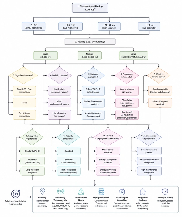
AI-Driven Capabilities for Indoor Navigation
AI adds value to indoor navigation when positioning information is connected to operational context. A location estimate by itself may show where a person, vehicle, or mobile asset is located, but AI can analyze sequences of location events to determine what is happening, identify deviations, and support operational decisions.
H3: AI Route Optimization and Dynamic Wayfinding
Static indoor routes assume that corridors, rooms, entrances, elevators, and other paths remain available. Real facilities rarely behave that way. Construction work, temporary closures, maintenance activity, crowding, security restrictions, and operational changes can make a previously optimal route unsuitable.
AI-based routing can evaluate current location data together with mapped facility constraints and historical movement patterns. A navigation application can therefore select a route based on factors such as congestion, accessibility, restricted zones, estimated travel time, or temporary obstructions.
For example, a large hospital can use indoor positioning data to identify congestion around registration, imaging, emergency departments, elevators, and major corridors. A navigation system can use this information to recommend alternative paths where operational rules permit.
Movement Pattern Analysis
Continuous indoor location events create a time-series dataset describing how people and assets move through a facility. Machine learning can analyze this data to identify recurring movement patterns, unusually long dwell times, frequently congested areas, and inefficient routes.
Warehouse operations provide a particularly useful example. If workers repeatedly travel long distances between picking locations and staging areas, location analytics can reveal the pattern. Operations teams can then evaluate storage-zone assignments, task sequencing, aisle utilization, and route design.
The same approach can be applied to manufacturing facilities. Repeated movement between maintenance stores, production cells, inspection stations, and tool rooms may indicate opportunities to reorganize workflows or reposition frequently required resources.
Indoor Location Anomaly Detection
AI can establish expected movement behavior and identify events that differ significantly from historical patterns. An anomaly does not automatically indicate a security incident. It can represent an unusual operational condition requiring human review.
Examples include:
- A mobile asset remaining in an unexpected zone for an extended period.
- A service worker entering a restricted operational area.
- A navigation route repeatedly becoming unavailable.
- A normally low-traffic corridor experiencing sustained congestion.
- A tagged asset moving through an unexpected sequence of facility zones.
- Location data suddenly becoming inconsistent because of gateway or beacon problems.
Anomaly detection is most effective when alerts are associated with operational rules and appropriate escalation procedures rather than generating alerts for every deviation.
AI-Assisted Facility and Asset Visibility
Indoor navigation can be combined with asset location information to provide context around equipment and resources. A maintenance team, for example, may use a location-aware application to identify where a tagged tool or mobile device was last observed.
AI can extend this capability by analyzing historical location patterns. Frequently moved equipment can be identified, unusual asset movement can be flagged, and recurring searches for particular resources can reveal process inefficiencies.
The technical objective is not simply to collect more location data. It is to convert location observations into information that supports measurable operational decisions.
Indoor Navigation Performance, Scalability, and Business Value
The value of an AI indoor navigation solution should be evaluated against measurable operational outcomes. Positioning accuracy is important, but it is only one part of system performance. A technically accurate location service can still provide limited value if maps are outdated, integrations are incomplete, alerts are excessive, or users do not act on the information.
Key Performance Indicators for Indoor Navigation
Relevant KPIs vary by facility and application, but useful measures include:
- Positioning accuracy by zone or facility area.
- Median and percentile location error.
- Route recommendation accuracy.
- Average navigation time between defined locations.
- Successful route-completion rate.
- Indoor navigation application response time.
- BLE observation availability.
- Gateway connectivity availability.
- Location-event processing latency.
- Percentage of valid location observations.
- False-positive and false-negative rates for anomaly detection.
- Congestion detection accuracy.
- Average asset search time.
- Reduction in unnecessary movement.
- Average dwell time within designated operational zones.
- System availability during network interruptions.
- AI model drift over time.
- Battery life of deployed BLE devices.
- Gateway coverage and packet reception performance.
- API integration success rate.
A useful commissioning process establishes baseline measurements before AI optimization. Otherwise, teams may not be able to distinguish actual improvement from normal operational variation.
Scalability Across Buildings and Facilities
Scaling indoor navigation from one building to multiple facilities introduces additional engineering requirements. Floor plans, coordinate systems, BLE configurations, gateway inventories, network settings, user permissions, and software integrations must remain manageable as deployments grow.
A repeatable installation methodology can reduce commissioning effort. Standardized device naming, gateway identification, floor and zone conventions, configuration backups, firmware-management procedures, and documentation can make subsequent deployments more predictable.
AI models also require attention during scaling. A model trained using signal characteristics from one building may not perform identically in another facility because construction materials, room layouts, equipment, radio interference, and device density differ. Model validation should therefore include representative data from each materially different environment.
Reliability and Maintenance
Indoor navigation is an operational service, so maintenance cannot stop after installation. BLE beacons may require battery replacement, gateways may require firmware updates, and facility changes can invalidate portions of the positioning model.
A practical maintenance program should include:
- BLE beacon battery monitoring and replacement schedules.
- Gateway health and connectivity monitoring.
- Firmware and configuration management.
- Periodic positioning accuracy surveys.
- Floor-plan and zone updates following facility modifications.
- AI model performance monitoring.
- Detection of unusual changes in RSSI distributions.
- API and integration health checks.
- Cybersecurity patching and credential rotation.
- Backup and recovery testing.
- Documentation of device locations and configuration parameters.
Facility renovations deserve particular attention. Moving walls, installing large metal structures, changing storage racks, or relocating machinery can alter radio propagation and reduce the accuracy of a previously calibrated positioning system.
Indoor Navigation System Lifecycle: Continuous Optimization and Maintenance
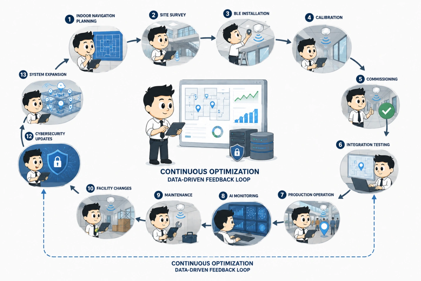
This lifecycle diagram illustrates the continuous process of managing an indoor navigation system, from planning and BLE installation through calibration, operation, AI monitoring, maintenance, cybersecurity updates, and system expansion. It highlights how operational feedback drives ongoing optimization and recalibration.
Integration with Indoor Navigation and Enterprise Software
Indoor positioning becomes significantly more useful when location events can be consumed by existing applications. A standalone map may demonstrate the technology, but production deployments usually require integration with systems that already manage people, assets, work orders, facility information, or operational tasks.
Common Software Integrations
Potential integrations include:
- Warehouse management systems: Location events can complement picking, staging, inventory movement, and warehouse task workflows.
- Computerized maintenance management systems: Equipment location can provide additional context for maintenance requests and work orders.
- Enterprise asset management software: Asset position and movement history can supplement equipment records.
- Facility management software: Indoor location can support space utilization, service coordination, and facility operations.
- Workforce management systems: Location information can support selected operational workflows where permitted by organizational policies.
- Hospital information and operational systems: Indoor wayfinding can connect facility maps with patient, visitor, staff, or equipment workflows according to applicable privacy and security requirements.
- Security and access-control systems: Location events can provide supplementary situational information when integrated with authorized security processes.
- Business intelligence software: Historical positioning data can be analyzed alongside operational metrics.
- Custom mobile applications: APIs can provide indoor maps, location data, navigation instructions, and alerts to facility-specific applications.
Middleware can normalize data formats and separate BLE-specific processing from business applications. This reduces the need for every application to understand individual beacon identifiers, gateway protocols, RSSI measurements, or positioning calculations.
API and Location Data Design
A well-designed integration should define what constitutes a location event, how coordinates and zones are represented, how timestamps are generated, and how uncertainty is communicated.
For example, a useful location record may include a device identifier, estimated position or zone, timestamp, confidence value, source gateway information, and event type. Applications can then decide whether a particular observation is sufficiently reliable for their workflow.
Data schemas should also accommodate changes. Facility zones may be renamed, floor plans may change, and devices may be replaced. Stable identifiers and version-controlled spatial data can reduce integration problems during long-term operation.
Cybersecurity and Data Governance for AI Indoor Navigation
Location information can become sensitive operational data because it may reveal movement patterns, restricted areas, facility layouts, equipment positions, or workforce activity. Security controls should therefore be designed into the indoor navigation system from the beginning.
Device and Network Security
BLE devices and gateways should use appropriate authentication and configuration controls. Gateways should be placed on networks consistent with organizational segmentation policies, while unnecessary services and exposed interfaces should be minimized.
Data transmitted between gateways and software should use appropriate encrypted protocols. Administrative interfaces should use strong authentication and role-based authorization. Logs should capture relevant configuration changes, authentication events, software errors, and security events.
Private server deployments may provide organizations with greater control over where location information is processed and stored. Cloud deployments can also be secure when properly configured, but organizations should evaluate identity management, encryption, access controls, network connectivity, data retention, and regulatory requirements as part of their deployment assessment.
AI Model Governance
AI models introduce additional operational considerations. Model performance can decline when the physical environment changes, when device populations change, or when signal characteristics shift.
Teams should monitor:
- Prediction accuracy and location error.
- Model drift.
- Changes in signal distributions.
- Training-data quality.
- Inference latency.
- False alerts.
- Model version and deployment history.
- Data used for retraining.
- Human review of significant automated decisions.
AI should support operational personnel rather than obscure the basis for important decisions. Confidence scores, event histories, and explainable operational rules can make AI-generated recommendations easier to validate.
Security and AI Governance Matrix for AI-Powered Indoor Navigation Systems
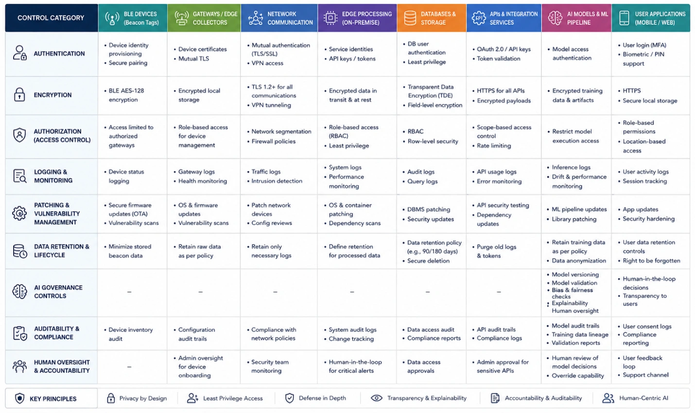
This matrix maps essential cybersecurity and AI governance controls across the full indoor navigation ecosystem, from BLE devices and gateways to AI models and user applications. It highlights authentication, encryption, authorization, monitoring, patching, data retention, auditability, model governance, and human oversight. The key takeaway is that secure and trustworthy AI requires controls across every system layer.
Deployment Recommendations for AI Indoor Navigation
Successful deployment generally depends on disciplined engineering rather than simply increasing beacon density or selecting a more sophisticated AI model.
Plan Around the Indoor Navigation Workflow
Start by defining the operational problem and the movement workflow. Determine whether the objective is navigation, zone detection, congestion analysis, asset visibility, emergency situational awareness, or a combination of these functions.
Different objectives require different positioning performance. Room-level navigation may require a different deployment than simple zone entry detection. Designing for unnecessary precision can increase hardware, installation, calibration, and maintenance requirements without improving the actual business outcome.
H3: Conduct a Representative Indoor Positioning Site Survey
A site survey should evaluate walls, ceilings, floors, metal structures, racks, machinery, elevator areas, people density, existing wireless infrastructure, gateway mounting locations, power availability, and network connectivity.
Testing should occur under representative operating conditions. A quiet empty building can produce different BLE signal behavior from the same facility during normal working hours.
Calibrate Before Applying Advanced AI
Positioning accuracy should be measured before deploying sophisticated AI optimization. Engineers should identify whether errors originate from beacon placement, gateway coverage, signal propagation, map coordinates, device behavior, or positioning algorithms.
AI is most valuable when it improves an already sound data pipeline. Feeding poor-quality observations into a more complex model does not automatically create better location information.
Pilot Critical Navigation Workflows
A pilot should represent actual operating conditions and include real users, relevant devices, typical movement paths, and the applications that will consume location data.
Testing should cover:
- Normal operation.
- High user density.
- Network interruptions.
- Gateway outages.
- BLE device failures.
- Facility access restrictions.
- Temporary route closures.
- Floor-plan changes.
- API failures.
- AI inference errors.
- Recovery after connectivity restoration.
Production acceptance criteria should be defined before the pilot begins.
Design for Long-Term Indoor Navigation Operations
Commissioning should include documentation of device locations, gateway configurations, software versions, maps, API endpoints, security settings, calibration data, and maintenance procedures.
GAO can support organizations evaluating BLE hardware and IoT systems for indoor positioning by helping align beacons, gateways, sensors, and related equipment with practical deployment requirements. GAO’s three decades of R&D investment and stringent quality-assurance processes support organizations that require technical hardware and remote or onsite expert assistance.
Implementing AI-Powered Indoor Navigation with GAO
AI and BLE for Indoor Navigation is most effective when treated as an integrated operational system rather than an isolated positioning project. BLE beacons, gateways, and sensors provide location observations, while positioning software, digital maps, edge processing, AI models, APIs, and operational applications convert those observations into useful decisions.
The strongest implementations begin with clearly defined indoor navigation and location workflows, measurable accuracy requirements, representative site surveys, disciplined commissioning, and appropriate cybersecurity controls. AI can then improve route selection, movement analysis, anomaly detection, congestion awareness, and operational planning.
GAO provides BLE gateways, beacons, sensors, RFID and IoT hardware, and related systems that organizations can incorporate into indoor positioning and location-based solutions. With operations serving customers in the U.S. and Canada for three decades, including Fortune 500 companies, leading R&D organizations, universities, and government agencies, GAO combines product engineering, quality assurance, and remote or onsite technical support. Organizations evaluating indoor navigation can learn more about GAO’s technology solutions, engineering expertise, and technical support options for facility-specific deployments.
Building the Future of Industrial AI and IoT with Aperture Venture Studio and GAO RFID Inc.
For more than three decades, GAO Group of Companies has invested heavily in R&D for industrial BLE, RFID, and IoT technologies. As generative AI has become increasingly useful for industrial applications, we have continued developing AI and IoT solutions, including technologies supporting indoor navigation, positioning, BLE, and RFID, while working with Aperture Venture Studio to advance practical AI and IoT solutions across industry applications.
Aperture has attracted AI and IoT technical experts, entrepreneurial and operational executives, influential investors, and leading companies. We have also developed Aperture Ventures Summit and TekSummit to discuss advanced AI and IoT topics and foster technical communities.
We welcome you to join us as:
- Advisors, co-founders, or employees
- Investors
- Customers